Atlas of Portugal
 |
Wikimedia Commons Atlas of the World The Wikimedia Atlas of the World is an organized and commented collection of geographical, political and historical maps available at Wikimedia Commons. Discussion • Update the atlas • Index of the Atlas • Atlas in categories • Other atlases on line |
|
| ||||||||||||||||||||||||||||||||||||||||
General maps
 |
Map of Portugal |
 |
Same map in Portuguese |
 |
Map of Portugal |
 |
Administrative divisions of Portugal |
 |
Divisions of Portugal |
 |
Municipalities |
 |
Portugal's Exclusive Economic Zone |
History maps
This section holds a short summary of the history of the area of present-day Portugal, illustrated with maps, including historical maps of former countries and empires that included present-day Portugal.
Early history
| [[|border|251x400px]] | Pre-Neanderthals |
| [[|border|251x400px]] | Neanderthals |
 |
Palaeolithic art |
 |
Distribution of the Y-DNA R1 haplogroup: R1a (purple) and R1b (red). |
 |
General map of Neolithic expansion in Europe, with some dates |
 |
Neolithicum in Europe 5th millennium BCE |
 |
Europe in ca. 4500 BC-4000 BC |
 |
Europe in ca. 4000 BC-3500 BC |
 |
Beaker culture |
 |
Extent of the Beaker culture (ca. 2800 – 1900 B.C.) |
 |
Pre-historic art in Iberia |

 |
The Iberian Peninsula (Spain and Portugal) in the bronze age |
Pre-Roman
 |
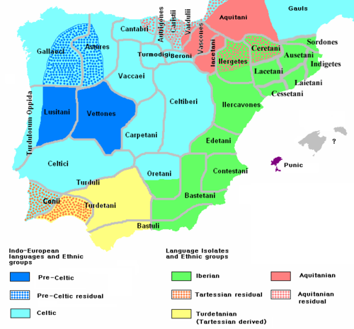
Pre-Roman tribes |
 |
Ethnographic Iberia 200 BCE |
 |
Prehispanic languages and tribes |
 |
Prehispanic languages |
 |
Paleohispanic writing systems excluding proper Lusitanian |
 |
Possible extent of (proto-)Celtic influence 800-400 BC |
 |
Celts in Europe |
| Celts in Iberia (200 BC) |
| Celts in Europe |
 |
Celts: Hallstatt (yellow) and La Tène (green) cultures |
Roman
 |
Territorial development of the Roman Empire 264 BC-192, including the conquest of present Iberia |
 |
The Roman Republic and Carthago in 218, just prior to the Second Punic War |
 |
The migrations of the Cimbri and the Teutons |
 |
Roman Republic 100 BCE |
 |
Map of the Roman Empire in 50 |
 |
The extent of the Roman Republic and Roman Empire; 133 BC 44 BC (late Republic, after conquests by republican generals) AD 14 (death of Augustus) 117 (maximum extension) |
 |
Map of the Roman republic, with provinces |
 |
Hispania under the Roman republic |
 |
Map of the Roman Empire in 116 |
 |
Lusitania in the Roman Empire (116) |
 |
Roman Empire in 117 |
 |
Astur-Cantabrian war |
 |
Hispania under Octavio César Augusto (29-19 a. J. C.), after the Cantabrians Wars |
 |
Hispania under Diocletian, 293 AC |
 |
Hispania under Hadrian, 125 AD |
 |
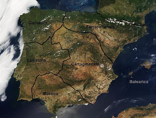
Roman provinces in Iberia |
 |
 |
Roman province of Lusitania |
 |
Roman Lusitania |
 |
Roman Empire divided 395 |
 |
The division of the Empire after the death of Theodosius I, ca.395 AD superimposed on modern borders. |
 |
Western Roman Empire 395 |
 |
Invasions of the Roman Empire 100-500 |
 |
Invasions of the Roman Empire 100-500 |
 |
Division of the Roman Empire in 406 |
 |
Iberia in 409-429 |
 |
Iberia in 411 |
 |
Iberia in 411 |
 |
Iberia in 418 |
 |
Kingdom of the Alans, 409-426 |
Visigoths and Suevi
 |
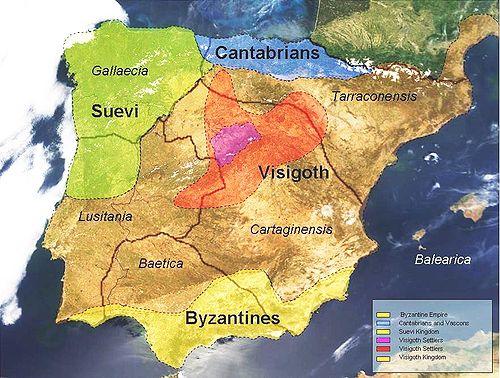
Iberian Peninsula Around 476 AC |
 |
Iberian Peninsula Around 560 AC |
 |
Iberian Peninsula Around 560 AC |
 |
Iberian Peninsula in 565 |
 |
Iberian Peninsula Around 586 AC |
 |
Visigoths migrations |
 |
Kingdom of the Visigoths |
 |
Visigoths and Sueves |
 |
Kingdom of Suvean Galicia |
 |
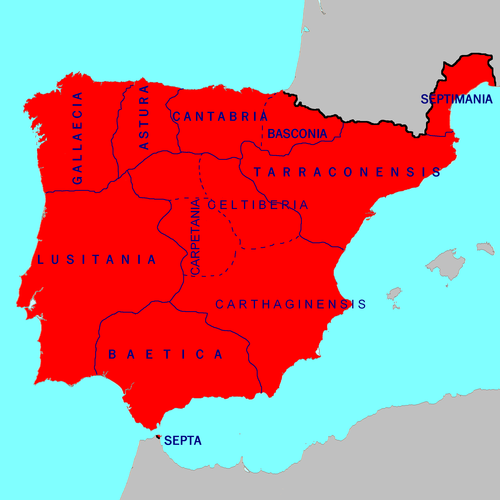
Iberian Peninsula in 700 |
Muslim Iberia and Reconquest
 |
Conquest by the Caliphs |
 |
Caliphate around 750 |
 |
Europe in 814 |
 |
Empire of the Almoravides (in English) |
 |
Emirate of Cordoba |
| File:Iberia 1031 (norsk).jpg | Iberia in 1031 |
| [[|border|251x400px]] | Iberia in 1031 |
 |
Taifas in 1080 |
| [[|border|251x400px]] | Reconquista |
 |
Reconquista |
 |
 |
Habsburgs
 |
Habsburg Empire in 1547 |
 |
Area ruled by the Habsburg king around 1580 on a map showing modern-day state borders |
Portuguese Empire
 |
Empire at João III reign |
 |
Portuguese colonial possessions in the XVI century |
 |
Portuguese territory in the XVIII century |
 |
Territorial demarcations between the Portuguese and Spanish empire, resulting from the treaties of Tordesilhas, Saragoça and Alcáçovas (in German) |
 |
Portuguese posessions during the Spanish rule (1581-1640)(in blue) |
 |
Dutch-Portuguese War 1588-1654 |
 |
Portuguese possessions in India 16-18 th centuries |
 |
Brazilian administrative division as of 1789 |
 |
Portuguese Empire 1916-1974 |
| Portuguese colonies in Africa by the time of the Portuguese Colonial War (1961-1974) |
 |
Anachronous map of the Portuguese Empire (1415-1999) |
 |
Portuguese speaking countries |
 |
Portuguese linguistic sphere resulting from the colonization process |
Other
 |
Historical provinces of Portugal |
Old maps
This section holds copies of original general maps more than 70 years old.
 |
Map of Portugal in 1561 in the "Theatrum Orbis Terrarum" (1570) de Abraham Ortelius |
 |
Portugal in 1905, Bibliothek allgemeinen und praktischen Wissens für Militäranwärter Band I, 1905 |
Maps of the Azores
 |
Location of Azores |
 |
Location of Azores with Island names |
 |
Map of the Azores |
 |
Map of the Azores (Portuguese) |
 |
Luís Teixeira map of the Azores (c. 1584) |
Maps of Madeira
 |
Location of Madeira |
 |
Location of Madeira |
 |
Ilhas Selvagens |
Satellite maps
 |
Satellite map |
Notes and references
|
General remarks:
|

