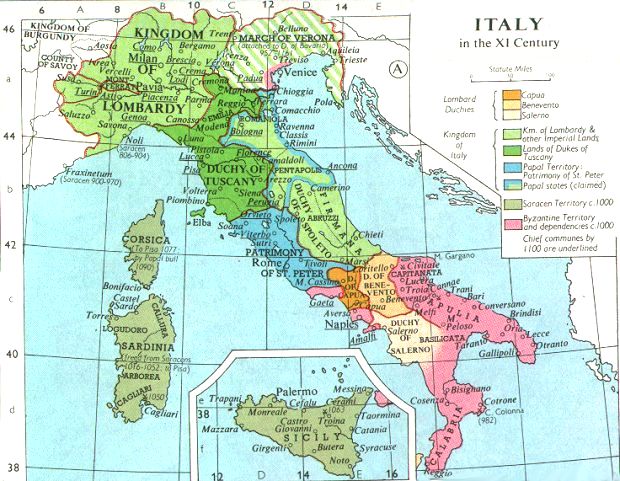
File:Italy 1000 AD-fr.svg

| Uploaded by | Sémhur |
|---|---|
| Upload date | 2008-12-29T12:15:26Z |
| MIME type | image/svg+xml |
| Dimensions | 564 × 810 px |
| File size | 186.5 KB |
Summary
| Description |
English: Political map of Italy in 1000 AD (CE).
Français : Carte politique de l'Italie en l'an mille. |
| SVG development | |
| Date | |
| Source |
|
| Creator |
|
| Geotemporal data | |
| Heading |
 |
| Georeferencing | If inappropriate please set warp_status = skip to hide. |
| Other versions |
Derivative works of this file: SVG:
PNG:
|




| Camera location |  | View this and other nearby images on: OpenStreetMap |  |
|---|

Licensing
I, the copyright holder of this work, hereby publish it under the following licenses:

|
Permission is granted to copy, distribute and/or modify this document under the terms of the GNU Free Documentation License, Version 1.2 or any later version published by the Free Software Foundation; with no Invariant Sections, no Front-Cover Texts, and no Back-Cover Texts. A copy of the license is included in the section entitled GNU Free Documentation License. |
  
|
This file is licensed under the Creative Commons Attribution-Share Alike 3.0 Unported license. | |
| ||
| This licensing tag was added to this file as part of the GFDL licensing update. |
You may select the license of your choice.
Category:CC-BY-SA-3.0-migrated
Category:Files modified by User:Sémhur
Category:Files with coordinates missing SDC location of creation
Category:Files with derivative versions
Category:French-language SVG maps showing history
Category:GFDL
Category:License migration redundant
Category:Map Lab-fr
Category:Maps by User:Sémhur
Category:Maps of Italy in 1000
Category:SVG created with Inkscape:Important
Category:SVG maps:Translation possible
Category:SVG maps of the history of Italy
Category:Self-published work
Category:Valid SVG created with Inkscape:World maps