Visby
| Camera location | | View all coordinates using: OpenStreetMap |
|---|
|
This place is a UNESCO World Heritage Site, listed as
Hanseatic Town of Visby.
|
|
This is a a file of a national interest for cultural heritage in Sweden with the number I20 in accordance to the 3rd and 4th chapter in the Swedish Environmental Code. |
English: The Hanseatic town Visby is the description of Visby, Sweden, from the UNESCO World Heritage Committee.
Visby was founded in the 10th century, on the then independent Baltic Sea island of Gotland. The Hansaetic League formed it during ensuing centuries, during which it came to Denmark. In 1645, it came into Swedish occupation, in which it has remained until today.
Category:Uses of Wikidata Infoboxtown of the Hanseatic League in Sweden  | |||||
| Upload media | |||||
| Instance of | |||||
|---|---|---|---|---|---|
| Location | Visby, Region Gotland, Gotland County, Sweden | ||||
| Has part(s) | |||||
| Heritage designation |
| ||||
| Different from | |||||
 Category:Uses of Wikidata Infobox with maps Category:Uses of Wikidata Infobox with maps | |||||
| |||||
Photos
 Panorama
 satellite image
 The harbor
 City walls
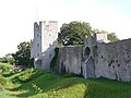
 A tower in the wall
 Strandpromenaden
 Almedalen
 Fishermans Alley
 Packhusplan square
 Street
 Drotten Church
 Helgeand Church
 St Clemens Church
 St Lars Church
 St Olof Church
 St Per and St Hans
 St Gertrud Chapel
 St George Church
 Model of Visborg Castle


.jpg)


