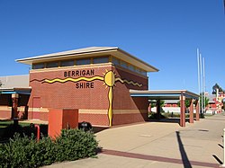
Berrigan, New South Wales
English: Berrigan, New South Wales
Category:Uses of Wikidata InfoboxCategory:Uses of Wikidata Infobox with no imagetown in New South Wales, Australia | |||||
| Upload media | |||||
| Instance of | |||||
|---|---|---|---|---|---|
| Location |
| ||||
| Population |
| ||||
| Elevation above sea level |
| ||||
| Connecting line | |||||
 Category:Uses of Wikidata Infobox with maps Category:Uses of Wikidata Infobox with maps | |||||
| |||||
This page is a part of the larger project Towns of the Riverina, New South Wales. For information on the town see the wikipedia article.
Banks
- The former Commonwealth Bank, now a residence
- The former National Australia Bank, to be demolished in February 2007.
Hotels
- The Momalong Hotel. Now a residence and second hand shop
- The Federal Hotel
- The Berrigan Hotel, no longer operating
- The Royal Hotel
Public buildings
- Berrigan Shire Office
- Berrigan Shire Office, after library construction
- Library, built in 2008
- The ambulance station.
- RSL sub branch building
- Post Office
- Hospital, built in 2008
- CWA hall and Federation monument
- Masonic hall
- St Columba's Roman Catholic church
- War memorial swimming pool
- Berrigan Public School, established in 1891
- Community Health Centre
Shops
- Chanter St, Berrigan, looking east
- Chanter St, Berrigan, looking west
- Riverina Highway intersection
- The butcher shop on Chanter St.
- Solicitor's office
- Another view of the office
- National Australia Bank and IGA supermarket
- Real Estate office
Churches
- St Columba's Catholic church
- Former Catholic church
- Uniting church
- Presbyterian church
- St Aidan's Anglican church
Houses
- The old doctor's residence
- Former convent
- Catholic presbytery
- House
- House
- House
Other
- RFS memorial.
- Bowls tournament at Berrigan Golf and Bowls club
- Canola field
- "The Drop"
- Mulwala Canal
- Silos
- Centenary memorial
- World War II memorial
- World War II memorial
- Olive tree avenue memorial
- Skatepark


