The en: Golan Heights needs to be shaded. Possibly a different color to the rest of the Israeli controlled bit, but it's only recognized as part of Israel by the United States. Industrial Metal Brain (talk) 00:41, 9 December 2024 (UTC)
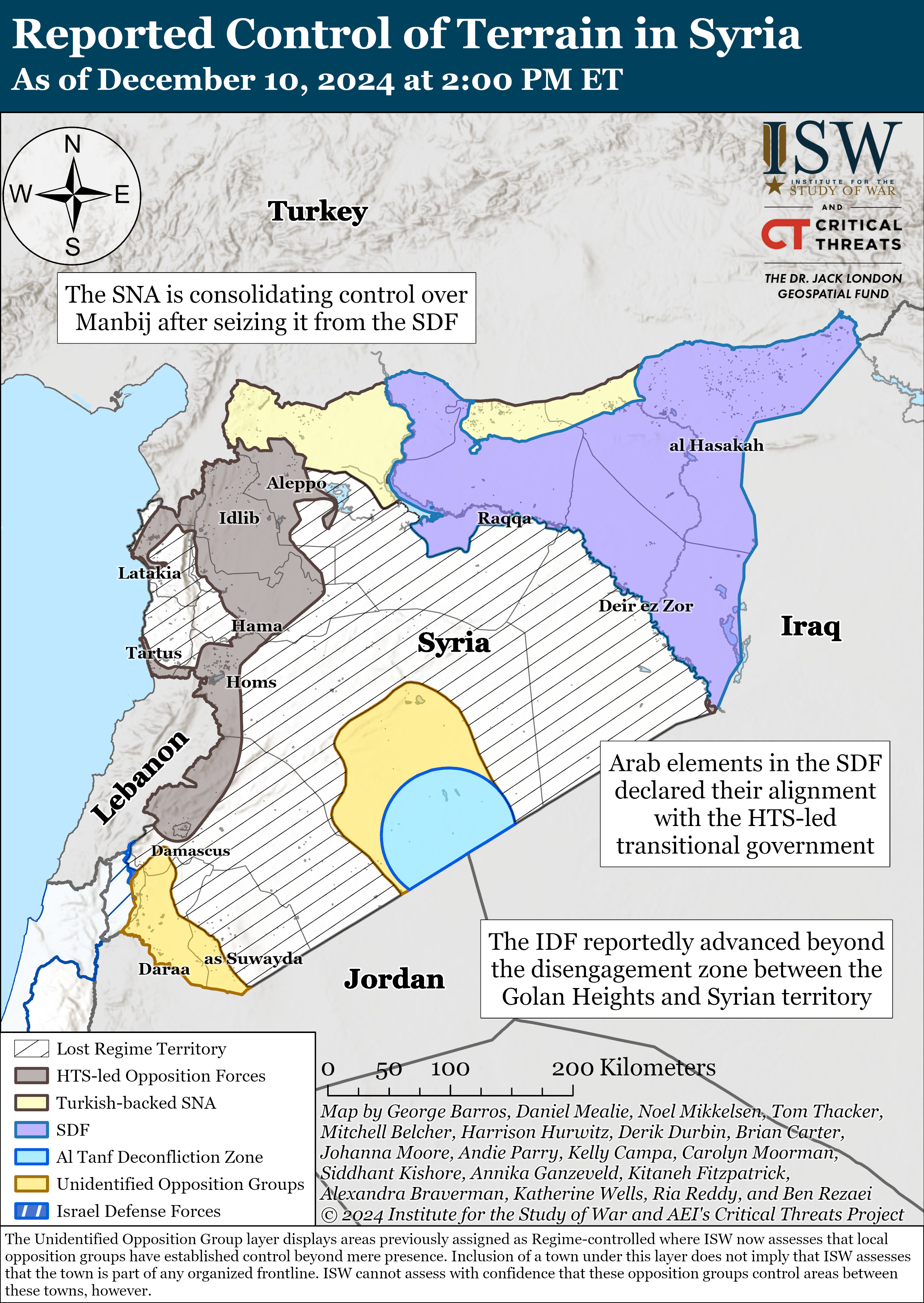
Manbij
The new offensive is not represented here Braganza (talk) 10:02, 9 December 2024 (UTC)
Deir ez-Zor governorate "SAA remnants" as well as supposed SIG presence need to be removed
Per https://syria.liveuamap.com/ the areas of the governorate not under SDF control are under rebel control; there is no SAA presence remaining. Also the rebels in question are affiliated with HTS not the Syrian Interim Government. Chessrat (talk) 11:22, 9 December 2024 (UTC)
Southern Operations Room has allegaince to the Syrian Transitional Government. shadowwarrior8 (talk) 21:58, 9 December 2024 (UTC)
Syrian transitional government or split-up Syrian opposition?
So far, at the time of writing, there have been a grand total of 7 12 back-and-forth reverts over whether there should be a split-up Syrian opposition or a unified Syrian transitional government. Please, let's make the decision final.
Option A: Use the status quo of a split-up Syrian opposition map
Option B: Use a unified Syrian opposition map, under the banner of the Syrian transitional government
Also just want to back up with an additional reason. Along with the fact they have not implemented a unification and still have different flags for one of them, they also don't agree on everything. Notably and important for this article, Israel. Some of the factions want peace. some are sharing bitter words about what's going on or statements about Golan, some Palestine rhetoric, and one group straight up tried to attack the Golan heights prompting the current invervention. TheBrodsterBoy (talk) 04:48, 10 December 2024 (UTC)
Option A Since there are no reliable sources saying that the opposition has united yet, in my opinion, using the status quo map makes the most sense. Physeters✉ 02:44, 10 December 2024 (UTC)
Option A per above. Leave it as it is. I hate having to change the infobox back and forth to match the colors on the map! Someone who's wrong on the internet (talk) 10:07, 10 December 2024 (UTC)
Option B is the only option which follows reliable sources– the claim of those specific divisions between the different factions' areas of control is entirely unsourced. Chessrat (talk) 10:34, 10 December 2024 (UTC)
Option B per chessrat Abo Yemen✉ 11:00, 10 December 2024 (UTC)
Option A war is still going in the North, the proposed Option B map shows Turkish areas in a different color from the newly occupied SNA territory which breaks the point. Option C proposal: Maybe make color them in similar greenish shades, so you recognize them as related but they are still seperated Braganza (talk) 14:58, 10 December 2024 (UTC)
Comment It's worth noting that the course of events means Option A is now blatantly incorrect– the ministers of the former Syrian Salvation Government are now instead taking up the same roles in the new Syrian transitional government in Damascus as of today. Chessrat (talk) 15:31, 10 December 2024 (UTC)
Conditional A or B: if we cease with updating this map and freeze it at 8 December 2024, then I support Option A; if we plan on continuing with updating the map with the Livemap source, then I support Option B. Gluonz (talk) 16:09, 10 December 2024 (UTC)
Option B which is supported by sources and ground events. HTS & SSG leaders are in Damascus and are currently leading the political transition phase of the Syrian Transitional government. It is very clear that Option A is incorrect.
Syria's opposition rebels have officially appointed Mohammed al-Bashir as the head of the Syrian transitional government... The caretaker government will also reportedly prepare the ground for a permanent government, adding that consultations are ongoing in a bid to form a government, the sources said. Ministers from the Syrian Salvation Government (SGG), which al-Bashir headed, will also cooperate with the caretaker government, according to the Qatari broadcaster.
HTS leader Abu Mohammed al-Jolani arrived in the capital, Damascus, on Sunday, and later met with Assad’s prime minister and vice president to discuss forming a new government. Al-Bashir, an engineer from Idlib, had previously served as a minister in the rebel-controlled northwestern region of Syria. Earlier this year, he was appointed the head of the government in that area, which was supported and financed by HTS but lacked international recognition. The decision to appoint Al-Bashir followed a meeting between him, HTS leader Ahmed Al-Sharaa (al-Jolani's real name), and current prime minister Ghazi al-Jalali, according to Arabiya TV.
Opposition leader Ahmed al-Sharaa, also known as Abu Mohammed al-Julani, met outgoing Prime Minister Mohammed al-Jalali on Monday to discuss the transition. Al-Jalali, who served under al-Assad, has agreed to transfer power to Hayat Tahrir al-Sham’s (HTS) Syrian Salvation Government (SSG). ... The transitional government is to be formed by Mohammed al-Bashir, who is close to the HTS – the group that led the Damascus takeover – and heads their Idlib-based SSG.
Option A is the only Option which is true and that makes sense. The other option is completely brainrot. The War is not over. Arminia4ever (talk) 17:54, 10 December 2024 (UTC)
Option B, only because the one @Ecrusized made is more up-to-date. But if the file currently up ever gets updated, then I’d be fine with both options. Zabezt (talk) 19:19, 10 December 2024 (UTC)
Option B' - the current map is not being updated, the displayed divisions between areas of control of rebel groups are completely unsourced, and even contradicted by reporting (e.g. rebel cells south of the Euphrates declaring allegiance to SNA / Fajr al-Hurriya ops room, HTS at Sednaya, Jolani in Damascus, Maghawir al-Thawra supposedly controlling all of Rif Dimashq with a few hundred fighters, the Southern Front working with HTS-led ops room, it's not that the opposition united under HTS, but that the institutions of the existing / transitional government are working in the entire country, aside from the Turkish- and Israeli-occupied areas and AANES color to indicate transitional government control with footnote about different rebel groups, uncertain command structure, etc. is better than uncertain division and imagined boundaries - which groups captured where is sourced, but these divisions in control are totally unsourced) 130.74.59.235
Option B. Per Chessrat. It’s not the job of Wikipedia editors to pick and choose which parts of the territory belong to whom, based on their own assessments from a basement chair. We don’t have a reliable, detailed on-the-ground assessment, and the best we have is Liveuamap, which we’ve been using without issue for years. If and when intra-rebel faction conflict becomes real, Liveuamap will reflect that accordingly. Not to mention, this will also greatly slow down the process of tracking territorial changes between rebels and SDF that happen on a daily basis. JahlilMA (talk) 01:21, 11 December 2024 (UTC)
Very true, and, to your point, deir ezzor was also captured by HTS and subordinate local groups and there is discussion of fighting for the 'seven villages' exclave across the euphrates previously held by the SNA. The situation is very fluid, and wikipedia's coverage is not helped by reversion, without arguments in its defense, without updating the map, even according to its current parameters. The discussion should be closed posthaste, just as the giraffe bashar will be closed up in sednaya inshallah very soon 130.74.58.96 07:27, 11 December 2024 (UTC)
Comment: It's worth pointing out that all the justification made for Option A is based on WP:OR. 1. The OR assumption that the factions are not united yet. (TheBrodsterBoy, Physeters, Someone who's wrong on the internet) 2. The OR assumption that the factions are still warring. (Braganza, Arminia4ever). I'm arguing that we simply have to follow Liveuamap color scheme because this is the source we've been relying on for years. It's not the job of Wikipedia editors to decide which faction controls which territories. JahlilMA (talk) 18:24, 11 December 2024 (UTC)
No, that isn't WP:OR. OR is that rebels have peace and the war is over. The war is not over. Rebels are still fighting. When the rebels stop fighting completely, the war is over and we can do Option B if you want. Arminia4ever (talk) 14:21, 12 December 2024 (UTC)
The original research is the boundaries between the rebel factions. For example, where is the evidence that the SFA, which only has a few hundred fighters, controls all of the towns and villages north and east of Damascus. Asarlaí (talk) 09:36, 13 December 2024 (UTC)
Tell me, where is the evidence that all the rebels are happy with each other? Arminia4ever (talk) 15:01, 13 December 2024 (UTC)
Comment: HTS-led alliance of Military Operations Command (which established the Syrian transitional government) has territorial control of Daraa, Damascus, Aleppo and Deir-ez-Zor. Source: "Syria war live tracker: Maps and charts" (Al-Jazeera)
"Military Operations Command, the rebel coalition consisting of Hayat Tahrir al-Sham (HTS), has taken the eastern Syrian city of Deir Ezzor from the US-backed, Kurdish-led Syrian Democratic Forces (SDF)."
Option B. As editors above have said, the way the map is divided between the Syrian Salvation Government, Syrian Free Army and Southern Front is not backed by reliable sources. For example, where is the evidence that the SFA, which only has a few hundred fighters, controls all of the towns and villages north and east of Damascus? The Turkish occupation and the AANES should be kept separate, of course. Asarlaí (talk) 22:08, 11 December 2024 (UTC)
ISW-CTP's Map on the Syrian Civil War
Option D. Switch to Institute for the Study of War'sdaily updated map as the source. [Edit: map has now been made, added here for reference.] It reflects that large parts of Syria have uncertain control. It also includes the US controlled region, which isn't in the LiveUAmap. My second choice is Option B, but we really need this map updated quickly more than we need perfect accuracy. —Korakys (talk) 23:49, 11 December 2024 (UTC)
Option A, we are not sure whether there will be further conflicts between HTS, SFA and SNA, and it is too early to merge them into one color. Nebulatria (talk) 04:29, 12 December 2024 (UTC)
Nebulatria, that's not the issue. The issue is the actual boundaries - the way they're divided is not backed-up by sources. Asarlaí (talk) 11:53, 12 December 2024 (UTC)
Option B because it is the only one that cites a source https://syria.liveuamap.com/. The former one does not cite any sources. And it is completely made up by some Wikipedia editors perception of who should control what in Syria, and it is also rather ridiculous, because it asserts that one of the rebel groups, RCA, controls a 1/3rd of the country, including the capital Damascus, among with many other large cities. This is despite the fact that this group having less than 500 fighters. Ecrusized (talk) 11:03, 13 December 2024 (UTC)
Option B. Simple as. The opposition is unified, and no control is quite misleading (especially when the Southern Front announced control over all of the Dara'a and Suwayda governorates)
Option A is also good-ish. But option D should be ditched PLMandarynka (talk) 12:53, 28 December 2024 (UTC)
As far as ISW is a quality source on Ukraine, they simply couldn't keep up with the advancements in Syria and missed key progress, such as HTS moving south of Salamiyah, and areas NE of Damascus (Dumayr in particular) being freed. Therefore instead of bickering on what faction controls what - when it isn't even important - just make it all one color. And to differentiate, the SNA could be a different shade of green or orange as someone else proposed below. PLMandarynka (talk) 12:56, 28 December 2024 (UTC)
Comment: I dont think that ISW-Critical threats map can even be used as "quality source" on Russia-Ukraine war or any wars involving the United States, NATO, and the State of Israel. @PLMandarynka @JahlilMA @Chessrat
Upon investigation, I found out that "Institute for the Study of War" is an American right-wing military think-tank which collaborates with the "American Enterprise Institite". The "American Enterprise Institute", which releases the "Critical threats" maps, is literally a neo-con think-tank[1] which is also rabidly pro-Nentanyahu.[2]
Since the ISW-Critical threats map is an extremely biased American and pro-Israeli neo-con propaganda source, it should not be used in mapping.
In the context of Syrian civil war, ISW-Critical threats map is also terriby outdated. Shadowwarrior8 (talk) 13:51, 1 January 2025 (UTC)
Bearing in mind the concerns raised by all editors I think there is a route that may be satisfactory to all sides. Namely:
1) Use the existing syria.liveuamap.com as a base source (option B from the poll); change the green for SNA to some other colour for distinctiveness (e.g. orange). Therefore have a colour scheme of: Green = Syrian government; yellow = AANES; orange = Turkey/SNA; blue = Israel.
2) In any areas for which reliable sources indicate that non-HTS government-affiliated militias have control, those can be marked in different shades of green (e.g. Daraa and Suweida under the SOR in a lighter green, Tanf and Palmyra under the SFA in a different lighter green, etc). But make sure it is sourced (so no covering a third of Syria in SFA colors with no source for that)
3) Similarly if there are any areas where sources show that liveuamap is wrong, don't follow liveuamap (e.g. Manbij is under SNA, not the government)
So to summarize
Green = government
Other shades of green = government-loyal areas primarily controlled by non-HTS militias
Other colours = areas not loyal to the government
If a militia becomes loyal to the government or ceases to be loyal then their colour can be changed from different colour to a shade of green, and vice versa.
i like it Braganza (talk) 16:06, 13 December 2024 (UTC)
Now I like it too Arminia4ever (talk) 17:14, 13 December 2024 (UTC)
Good idea, I support this. It has recently been reported that HTS and the southern rebels were co-ordinating for the past year so I expect their colours to merge in most sources soon. Given that the southern group seems to be a collection of 25 different factions and the eastern rebels around Deir Ez Zor are not directly part of HTS it may be easier to merge all non-HTS rebels pledging loyalty to Damascus to all have one colour. @Kaliper1: might wish to comment. Korakys (talk) 09:19, 14 December 2024 (UTC)
@ChessratComment: The issue with Live.UA is its tendency to overestimate and speculate. I would assume that, starting from point number three, this map will no longer rely primarily on Live.UA and will instead draw from mixed sources. If that’s the case, it’s good, but I still think it’s somewhat arbitrary. I’m not saying editors don’t generally adhere to sources or that this file is completely based on Live.UA. To some extent, that’s not really the case. Editors have arbitrarily added small dots for villages based on their own assumptions. Maybe shift border minorly, here and there. But remember that Live.UA no longer shows differing groups. It’s not impossible to show, but I’m not aware of any alternative mapping sites that present a fragmented opposition that follow's live.UA's map prior to the merge. Maybe the closest is ISW and we could integrate the info from, but the contrast between the two is staggering, so shifting from a majority Live.UA-based backbone for border changes to a mixed approach still feels off and arbitrary. Which would primarily leaves to self-source?
-------------
TLDR: Its good. While shifting to mixed sources might help, the overall approach still feels inconsistent and unsupported. Integrating something like ISW data or self-source is possible, but big differences between sources make these changes seem unreliable and questionable. a 'hodgepodge' if you will. Kaliper1 (talk) 03:33, 15 December 2024 (UTC)
Though personally that's a small issue, my main problem would be that the colors are still too close to each other. There is only very little shades of green that are different extremes to each other to an extent that its eligible for those of the colorblind. Kaliper1 (talk) 02:05, 8 January 2025 (UTC)
I support this. Gluonz (talk) 16:29, 14 December 2024 (UTC)
Good proposal. PLMandarynka (talk) 12:57, 28 December 2024 (UTC)
No opinion on whether it would be better to show the coalition forces separately or as one color. But if we're gonna use the same color, can we at least pick contrasting colors for Turkish backed forces and the coalition forces? Having two very similar shades of green is very confusing (and probably hard to see on many monitors!):) Captain EekEdits Ho Cap'n!⚓ 04:59, 10 December 2024 (UTC)
Note regarding recent edit war
In my capacity as an admin, I've restored the version that was present before the edit warring over how to display the opposition forces took place. There is currently discussion above (#Syrian transitional government or split-up Syrian opposition?) regarding this, and I would encourage editors to make their case there regarding how this map should look. — Red-tailedhawk(nest) 05:10, 10 December 2024 (UTC)
Dear commons editors,
I’m from the German Wikipedia and I saw the page in an article. Then a User told in an edit summary that the page was edited very often, I think to a bad version. Now, we’re having the good version back again. Administrators, please do so that this version will be final and not be bad again. It makes no sense to see the rebels in one color. So, please notice that. Arminia4ever (talk) 05:42, 10 December 2024 (UTC)
The Golan Heights are Syrian territory and should be shaded and indicated as Israeli occupied. 2001:4C4E:2484:5100:390F:F657:D164:73B9 09:40, 10 December 2024 (UTC)
I second this concern. The map colors Syria's Golan Heights in the same color it is using for foreign countries. This view is a fringe position held by Israel and the United States, and does not represent the consensus of the vast majority of countries and international bodies that recognize the Golan Heights as part of Syria. JasonMacker (talk) 18:32, 11 December 2024 (UTC)
I'd agree that Golan Heights is disputed territory that is de jure Syria and should be marked as such. Abzeronow (talk) 18:42, 11 December 2024 (UTC)
Since Israeli occupation is shown in the map around the Golan/Quneitra Buffer Zone, it would be better to show the entire Golan Heights as “Israeli occupation” in the map —Preceding unsigned comment added by GucciNuzayer (talk•contribs) 19:38, 11 December 2024 (UTC)
We've voted to keep the rebel groups separate, I don't want another switch back to the merged one. But the current one needs updates.
HTS has the grey zone, SNA captured the Manbij Pocket, SNA has a small bridgehead across the river and has secured the old tomb site there, SNA is on the outskirts of Maskanah and has taken the towns in the north of that district, SDF positions near Deir Ez Zor have defected to HTS. Also some of the borders in the south need adjusting, especially around Damascus. HTS has a lot more in the North and the RCA/Al-Tanf brigade has less on both sides. TheBrodsterBoy (talk) 19:00, 10 December 2024 (UTC)
AFAICT only the western part of the Manbij pocket has fallen. Kwamikagami (talk) 21:59, 10 December 2024 (UTC)
Looks like the whole thing has and a bridgehead near the pre-2015 Tomb site is established TheBrodsterBoy (talk) 22:37, 10 December 2024 (UTC)
Look, this is the problem we’re going to face when we let Wikipedia editors take it upon themselves to decide which territory belongs to whom. Seriously, can’t we all just accept that we have zero capacity to make a final call on this? Just stick to the Liveuamap scheme for now, and this won’t even be an issue. JahlilMA (talk) 01:26, 11 December 2024 (UTC)
That's the description in the file information. And yet, the map is suddenly no longer following Liveuamap, based on an arbitrary decision made by only a handful of Wikipedia editors? This map has relied on Liveuamap for the vast majority of the civil war, and now, suddenly, it's no longer considered a reliable source? What are the alternative sources to support the current map? JahlilMA (talk) 21:08, 10 December 2024 (UTC)
I mean we are following Livemap, just not their picture since it's only got one color scheme for Post-November 26 gains with zero distinguishing and blindly following it makes it look like the HTS is conquering Manbij. We're following what they actually say in the infodots and their original sources. TheBrodsterBoy (talk) 22:35, 10 December 2024 (UTC)
Your explanation makes much more sense than Tradedia's. That said, I still think it’s extremely difficult to make a territorial distinction based solely on the infodots available on the website. At the end of the day, OR is unavoidable. JahlilMA (talk) 01:13, 11 December 2024 (UTC)
It is not correct to say that "This map has relied on Liveuamap for the vast majority of the civil war." Liveuamap is not a reliable source. Therefore, "the description in the file information" ("This map cites https://syria.liveuamap.com/") is invalid. What is valid and was always written on the file is "Source: Own work, derived from the Template:Syrian Civil War detailed map." Also, was always written on the file is "Information to editors: This file is completely based on the Template:Syrian Civil War detailed map. If you want to change something here, you first need to make a properly sourced edit at the Templates' Module." Also, see section below on this talk page ("Solution to map problems"). Tradediatalk 23:03, 10 December 2024 (UTC)
"Liveuamap is not a reliable source" Why are you making this point only now? Why wasn’t reliability of Liveuamap an issue before, even before Assad’s fall? What are the alternative sources? JahlilMA (talk) 01:12, 11 December 2024 (UTC)
Live.UA was considered a relatively reliable source during the earlier, more stagnant phases of the Syrian Civil War when troop movements were slow, and frontlines remained largely unchanged. However, the rapid pace and scale of the 2024 Opposition offensives presented significant challenges to maintaining real-time accuracy in tracking troop movements and territorial changes. To address the vast and often sparsely populated regions, such as the deserts and rural villages of central Syria, the inland Syrian Coastal Mountain Range, and the Anti-Lebanon mountain range—areas with little active rebel presence during the regime's collapse—Live.UA relied on an interpretative approach. This involved filling territorial gaps based on notions of de jure occupation rather than de facto control. While not inherently unusual, this method oversimplified the complexities of occupation and administrative governance, leading to discrepancies in representation.
Another significant criticism of Live.UA's mapping was its consolidation of the Syrian Opposition into a single agglomerated entity under the transitional government, ignoring the lack of a unified agreement among the various competing factions. By forwarding this notion as de jure rule, Live.UA introduced inaccuracies that reduced its credibility to some editors, marking a critical breaking point in its reliability as a source for the conflict. I would personally rather switch to using ISW's Mapping as that's what the Ukraine-Russia War Editor team has largely done. Rather also to think that its much more reliable than Live.ua. Kaliper1 (talk) 14:19, 12 December 2024 (UTC)
and where are your reliable sources that there are 'areas of influence' between rebel factions, which align in many cases entirely with the borders of governorates?
the sad truth is that there are very few 'reliable' (i.e. legacy media / academic) sources that are not either out of date / not constantly updated, or wildly inaccurate or simplistic, or both
news articles for notable battles / captures and maps periodically updated by institutions such as the ISW, which you mention, but little in between
and certainly NOTHING AT ALL which would ground these boundaries that you have drawn in reality 130.74.58.96 07:30, 11 December 2024 (UTC)
Might I interest you with ISW? Kaliper1 (talk) 14:21, 12 December 2024 (UTC)
you yourself write
7- Another problem with amateur maps is that we do not know when they are guessing and when they are not. There is a major difference between the Wikipedia map and their maps. Our map marks towns (or bases, etc.) that we have information for. On the other hand, their maps color the whole territory assigning a control status to every area. Do they really have enough information to assign every area to a specific party? Do they have information to be able to draw the frontlines? Our map has started by marking all the towns for which we had information/sources. We did not have the aim to cover the whole Syrian territory. We prefer not to guess. If we do not have reliable sources/information about an area, we just leave it empty. 130.74.58.96 07:37, 11 December 2024 (UTC)
I agree with you and you have pointed to a frustration I have had for years. I did not put on the map, these points that you mention. Undisciplined editors keep wanting to put small points and more small points even without a reliable source. I keep fighting this and have done it for years... but there are too many undisciplined editors... They just love to put on the map every small village that exists. It's like an addiction. Any dot that is not based on a reliable source should be removed. Tradediatalk 17:47, 11 December 2024 (UTC)
Solution to map problems
The map is unreliable. It is being updated with unreliable sources or no sources at all. https://syria.liveuamap.com/ is not a reliable source. Below is a reminder on how to create a reliable map. Map discussions should take place at https://en.wikipedia.org/wiki/Talk:Control_of_cities_during_the_Syrian_civil_war and lead to the update of a reliable template. Once we have a reliable template then we can print screen it into a reliable SVG map picture file. I therefore call on everyone to go to https://en.wikipedia.org/wiki/Template:Syrian_Civil_War_detailed_map and help us have a reliable up to date template. Then, making a reliable SVG map becomes trivial.
Remember what happened to the Afganistan map? It was being updated with unreliable sources (or no sources) and ended up being deleted after a deletion discussion! Tradediatalk 11:41, 10 December 2024 (UTC)
Why are you making this point only now? Why wasn’t this an issue before, even before Assad’s fall? JahlilMA (talk) 01:10, 11 December 2024 (UTC)
I am making this point only now because I only now discovered that this source was being used. As many veteran editors in this area, I was not following this war (and Wikipedia articles about it) anymore thinking it was a done deal. After the crazy events of the last 2 weeks, I came back to look at it. I see that the standards have fallen to a very low level. This would not have happened if many of the veteran editors were still here. For years, we have kept the map reliable by using the method described in the chart above. If you take a look at the "Revision history" of the template map (https://en.wikipedia.org/w/index.php?title=Module:Syrian_Civil_War_detailed_map&action=history&offset=&limit=500) you will see that we are able to use many reliable sources. Tradediatalk 17:09, 11 December 2024 (UTC)
Before the Assad’s fall we never use liveuamap as a source of this map. Your statement makes me feel a little confused. Nebulatria (talk) 04:12, 12 December 2024 (UTC)
Deir Ez Zur captured by HTS from SDF following defections (And more broadly the South Eastern Front situation in general)
After a string of pro-HTS uprisings and defections and some alleged war crimes the HTS has moved in to seize the area from the SDF.
Again, this pretty much confirms they hold the Grey area there and with the SDF falling back or defecting pretty much all of it on that side of the river.
The current map is outdated in several ways or just inaccurate as we've spent two days arguing about a template. Alongside all the other arguments made, let me simply put it this way. HTS is now fighting the SDF even if not to the same level as the SNA. The Southern Command and Revolutionary Commando Army are not fighting the SDF. The HTS and RCA/FSA are not hostile to Israel, while the Southern Command had forces attack the UN Buffer zone and is skirmishing with them. Combining all 3 is going to misrepresent their views on both these groups(Only one of the 3 is hostile to Israel, only one of the 3 is fighting the SDF), and only merging two would misrepresent at least one of them (Merging the two smaller southern groups misrepresents the Israel situation and merging one of them with HTS misrepresents the SDF situation).
Just to start with fixing this corner, the grey area and the small Kurdish pockets we have around Deir Ez-Zor are all HTS held now. The border between them and Al-Tanf brigade also needs adjustment, there is zero evidence of them taking the T3 Pump Station, Helipad, and associated town. The only way there is from Arak just north which is confirmed HTS, and the direction of HTS movements elsewhere and the initial RCA attack to Palmyra back this up. (as well as statements of ISIS attacks in the area being haulted by HTS forces).
So, on specifically the matter of the South-East, it should look something like this example piece https://imgur.com/a/syrian-civil-war-southeastern-situation-based-on-current-sources-heVQywWTheBrodsterBoy (talk) 22:36, 10 December 2024 (UTC)
Suggest switching to ISW as source for map
The Institute for the Study of War publishes a map of control of Syria. In an effort to break the edit war deadlock I suggest switching to it. — Korakys (talk) 00:05, 11 December 2024 (UTC)
Why is switching suddenly an issue after Assad’s fall? Does Liveuamap no longer fit the OR perspective of Wikipedia users? This Syrian Civil War file/map based on Liveuamap should remain consistent and reflect their updates. If needed, we can create a separate file/map based on ISW’s intelligence and present them as distinct sources. JahlilMA (talk) 02:48, 11 December 2024 (UTC)
Agreed. The whole map should be redrawn with a bit more reluctance. According to THIS map by ISW, there are wide areas without any established ruling faction at the moment. RobiH (talk) 13:24, 11 December 2024 (UTC)
Oh for fricks sake, they don't disagree with eachother in terms of the actual data. Livemap just has a different graphical presentation, they DO mark the groups as different in the sidebar info or just go follow their source links.
Livemap Marks everything that isn't SDF or Pre-Offensive SNA the same. And even then, everything SNA has taken since is given the same generic 'rebel' color, and SDF was singled out years ago when it was a Kurdish only group and it hasn't been for years. Livemap's style kind of made sense in 2013 when it was dozens of rebel groups against the government, it just hasn't aged great.
There's a difference between the data actually disagreeing, and two sites simply using different graphics to potray things. Livemap is Government, Rebel, Kurds, ISIS. Other sources are more specific about rebel factions. Both of them agree on the same data and even Livemap usually lists the specific group in the sidebar or the original source does.
This exact misunderstanding is how the Yemen Civil War page had a gigantic Al Qaeda blob for years that didn't exist. A couple of sites in the early days of the conflict lumped all 'rebels' into one color, Al Qaeda, Houthis, ISIS. Then when that was partially fixed it left AQ with a ton of territory they had never had because the other two weren't specifically sourced to have it and it got leftover, which was made worse by people forgetting how it started and then AQ losing most of what they actually had was missed by the mainstream media and only noted by a few social media sites, so again, Wikipedia missed it for years.
LIVEMAP HAS GREEN FOR REBELS. OTHER SITES USE DIFFERENT COLORS FOR DIFFERENT REBELS. THEY DON'T ACTUALLY DISAGREE JUST ONE SIMPLIFIES THE PRESENTATION TheBrodsterBoy (talk) 23:35, 11 December 2024 (UTC)
Using LiveMap as a source has suddenly become very contentious. I suggest switching to ISW as a compromise position to just get some updates done, even if ISW is a less accurate source overall it is better than no updates. Personally I agree that the LiveMap colour scheme has suddenly become very inaccurate, but what matters most is breaking the edit war deadlock. —Korakys (talk) 01:23, 12 December 2024 (UTC)
ISW-CTP's Map on the Syrian Civil War
The Syrian Civil War map sourced from the Institute for the Study of War (ISW) and the Critical Threats Project (CTP) team is available under this map. Should we follow this interpretation, this map would provide a detailed and clear depiction of the various factions involved in the conflict, offering more precision than other sources like Livemap. It is updated directly by the ISW-CTP team, leveraging on-the-ground connections rather than relying solely on social media or video reports. I would like to note that ISW's interpretation of the map focuses on areas of "effective control," which represents territories actively governed or occupied by specific factions. As a result, large unoccupied or contested areas, particularly those not yet under firm rebel control, often appear as voids or unclaimed zones on the map. This approach prioritizes accuracy over speculative representation, but it may lead to noticeable gaps in the visual depiction of territorial influence across Syria. Though personally I am quite unsure if we should follow this approach as updates from Livemap is much more frequent than that of ISW-CTP. Kaliper1 (talk) 10:16, 12 December 2024 (UTC)
According to ISW much parts of the map are voided as it “represents territory that the Syrian Regime used to control before November 27, 2024, but no longer does. The intent of this layer is to visualize territory that the Syrian Regime no longer exercises control over. Opposition rebel groups are very likely operating in areas within the Lost Regime Territory layer. ISW-CTP will map –and where possible identify –these rebel groups’ verified presence when ISW-CTP collects enough data to do so.”
According to sourcing ISW-CTP themselves uses the US military’s doctrinal definition of control. Control is a tactical task that requires the commander “to maintain physical influence over a specified area to prevent its use by an enemy or to create conditions necessary for successful friendly operations.” ISW-CTP cannot assess with confidence the extent of control without visual evidence or authoritative sourcing. Kaliper1 (talk) 10:49, 12 December 2024 (UTC)
Oppose: As discussed elsewhere in this talk page, ISW-Critical threats map is terriby outdated.
Moreover, "Institute for the Study of War" is an American right-wing military think-tank which collaborates with the "American Enterprise Institite". The "American Enterprise Institute", which releases the "Critical threats" maps, is literally a neo-con think-tank[1] which is also rabidly pro-Nentanyahu.[2]
Since the ISW-Critical threats map is an extremely biased American and pro-Israeli neo-con propaganda source, it should not be used in mapping. Shadowwarrior8 (talk) 13:45, 1 January 2025 (UTC)
Oppose:
1.- There has been no infighting between the groups (except with SDF, but this isn't discussed),
2.- The map is outdated, and
3.- It paints a lot of land between opposing factions as "uncontrolled" mistakenly. PLMandarynka (talk) 14:59, 24 January 2025 (UTC)
Does the new regime (or the UN, for that matter) have a cartographer? — 🇺🇦Jeff G. ツ please ping or talk to me🇺🇦 15:35, 24 January 2025 (UTC)
US military’s doctrinal definition of control is a mistake I presume? Kaliper1 (talk) 16:08, 24 January 2025 (UTC)
Let's solove Edit war. Stranger43286 (talk) 04:24, 11 December 2024 (UTC)
The obvious solution is too use the green one. The one with multiple factions in extremely innacurate and goes off people randomly guessing where the frontlines are actually placed between the Syrian Opposition Factions. Another reason is that the syrian opposition have stayed united and there has been no reported infighting yet, and it seems that they have shared control over Damascus. My final reasoning is that it follows the source that is used for this map, liveuamap.com. Also, I think the green one just looks a lot cleaner. Enewio (talk) 02:08, 12 December 2024 (UTC)
Protected for 2 days
Protected again, this time for 2 days, to prevent edit-warring. We will be handing out blocks next. Bastique☎ let's talk! 17:45, 11 December 2024 (UTC)
You are vastly more patient than I am, Bastique. I've wiped the entire edit war as disruptive.
Folks, you have two options:
1) Come to an agreement about what data source / image to use (and stick to it) through discussion here
2) Create two different maps based on the two different parties' tastes, and take the discussion to the projects using the image(s)
There really aren't any other paths out of this. Both paths involve talking to each other and not around each other, so I suggest you get started with that. The Squirrel Conspiracy (talk) 18:46, 11 December 2024 (UTC)
just noticed this map was created and being used on several articles. Is this the same as the reverted version or different? Fantastic Mr. Fox (talk) 07:47, 13 December 2024 (UTC)
@Fantastic Mr. Fox It's different, the map used currently follows the source of the Institute for the Study of War in collaboration with the Critical Threats Project (see: [1]). The same sourcing the Russo-Ukrainian War Team currently follows.
TLDR:
Due to Live.UA’s decision, the source used since 2014, to integrate the groups through the announcement of a Transitional Government (without substantial sources to support the consolidation), an edit war ensued. One group wanted to separate each faction, while the other supported consolidating them into a single opposition group, following Live.UA’s lead. As a result, the map was locked from further editing. To break the deadlock, many articles began switching to the ISW-CTP source, which is more reliable and less speculative than Live.UA. I’m not really sure whether the map I’ve created will remain temporary, as the current SVG has been updated continuously since a decade ago, and only recently has it ceased to be updated. Kaliper1 (talk) 01:48, 15 December 2024 (UTC)
Take it to the Syrian transitional government or split-up Syrian opposition? section
Those advocating marking the area under the control of the Syrian government under three separate colours have no sources at all for their logic behind doing so, and yet keep bringing that unsourced and incorrect map back.
Unfortunately I don't think there's any choice at the point but to upload an entirely new file and retire this one, as too many editors such as yourself insist on reviving a map which is not only outdated but entirely wrong. Which is why I'd suggest that those who want to keep an accurate up-to-date map should upload a new file. It is worth stressing that there are literally no reliable sources claiming that the Syrian government's controlled area are divided between those three factions on those borders, so this is not a dispute based on sources but one based on "should we follow sources, or should we use an entirely fictional and incorrect map because we used it in the past" Chessrat (talk) 19:58, 11 December 2024 (UTC)
What the heck is fictional about the fact these are different groups. Military Operations Command(Led by HTS, though technically containing some other smaller groups also in Idilib who pledged alligence to them) were in Idilib and started this whole offensive, they're the ones who started this offensive, they took Homs and Hama.
The Revolutionary Commando Army were the guys who had been camping out in that American Base zone at Al-Tanf for years doing nothing, the closest to the original 2011 'moderate' rebels. They took Palmyra opportunistically once the SAA started collapsing and as shown in Livemap if you actually read the sources in the sidebar moved down the road from Palmyra and reaching the Damascus suburbs of Douma. They're smaller and weaker.
The Southern Command Front were originally a mix of militia groups in Daara(mostly either Druze forces or other older rebel factions), specifically the ones who weren't wiped out in 2017-2019's offensives there and who didn't take the offer to get relocated to Idilib. They're the former 'reconciled' militias who were allowed to remain in place as long as they stayed loyal to Assad. Once the situation for the government worsened they abandoned their prior agreements and rose up, linking up with eachother and capturing most of Southern Damascus.
These are not the same group. One ruled Idilib, one was camping out in a safe zone near an American Base, and one was in reconciliation with the government prior to the collapse. They're only geographically linked up now, they hadn't been for years. They also do not agree with each other on everything. The HTS and their followers are islamist as are many of the Southern forces while the RCA isn't. The Southern Command Front were the ones picking a fight in the buffer zone while the other two were advocating for peace with Israel. HTS and their MOC has been opportunistically attacking the SDF and backing Arab uprisings against their leadership in places like Deir Ez Zur while the RCA and Southern Front haven't. None of the 3 align fully on these.
And that's not even mentioning how badly the merged map screwed up the SNA. It gave their extremely well documented control of North Aleppo and Manbij to the HTS for some stupid reason just because the guy was blindly following LiveMaps incredibly misleading color scheme. Livemap shows their Pre-Offensive territory as seperate, but not their post offensive territory, Livemap is one website with one graphical interface and they got caught off guard. The actual sources they give DO distinguish between the 3 groups as do other maps like BBC and CNNs or ISWs. They are not 'disagreeing' with Livemap, Livemap just has a different way of presenting it graphically, follow their source trail and actually read the words and it all agrees fine. The SDF is seemingly not a point of contention, but I will note the only reason LiveMap singled them out as different when they otherwise blanket color stuff is a holdover from the Rojava days, the SDF isn't specifically a Kurdish group anymore and hasn't been for a while, that's what's causing some of their issues with MOC/HTS.
Ignore the Damascus area if you want, whatever, but can we at least fix the Manbij and Southeast areas? The situation has calmed down for now as the US has held back Turkey for the time so it would be a good time to catch up. TheBrodsterBoy (talk) 23:29, 11 December 2024 (UTC)
Your long rant is just a series of WP:OR. You are not the expert on this field, just a Wikipedia editor. Even three users like you can't reach any consensus on which group controls which territory. Just stick to Liveuamap color scheme for this file. Go ahead and create a new file for a detailed assessment. JahlilMA (talk) 00:04, 12 December 2024 (UTC)
Liveuamap aren't experts either. The map was started originally by Ukrainians and expanded to use tweets for other conflicts. They decided to randomly merge all the rebels except the SNA (?) after Damascus fell but that's not what the situation is according to multiple sources. All the sources for example say Manbij fell to the SNA but the liveuamap as brodsterboy said is shown as part of the unified lighter green blob. Why? Problem with Wikipedia is even using basic common sense from sources is immediately slapped as "original research." It ain't.
Even I got blocked from editing the map for making one edit in the so called "edit war" for simply pointing out that even Liveuamap had the rebels separate for the entire time before Dec 8. See for yourself they have a past maps feature. Timetorockknowlege (talk) 00:09, 12 December 2024 (UTC)
If you have better sources for the map, go ahead and propose them. We've had no problems following Liveuamap for years, only now has it become a problem because it's not based on your OR understanding. Your "common sense" is not a qualification for your sources. JahlilMA (talk) 00:20, 12 December 2024 (UTC)
But Livemap's individual sources do distinguish between the groups, just not their final graphical presentation. TheBrodsterBoy (talk) 00:43, 12 December 2024 (UTC)
We are discussing how to draw the map. There's no better reliable graphical presentation that distinguishes between the former Syrian opposition groups, and that's the end of the discussion. JahlilMA (talk) 00:54, 12 December 2024 (UTC)
They aren't combining them into one giant blob. Timetorockknowlege (talk) 02:42, 12 December 2024 (UTC)
We aren't copying someone else's map 1-1, we're supposed to find sources stating who controls what to paint the dots on the svag thing TheBrodsterBoy (talk) 04:55, 12 December 2024 (UTC)
"For years"? If you look at the history of this file, you will find that Liveuamap was never used as a source before the fall of Assad. Why do you think this source was used for so long? Nebulatria (talk) 04:08, 12 December 2024 (UTC)
HTS-led alliance of Military Operations Command (which established the Syrian transitional government) has territorial control of Daraa, Damascus, Aleppo and Deir-ez-Zor. Source: "Syria war live tracker: Maps and charts" (Al-Jazeera)
"Military Operations Command, the rebel coalition consisting of Hayat Tahrir al-Sham (HTS), has taken the eastern Syrian city of Deir Ezzor from the US-backed, Kurdish-led Syrian Democratic Forces (SDF)."
I've collapsed this discussion because there's no reason for it to be here instead of where everyone else is discussing the map, at #Syrian transitional government or split-up Syrian opposition? above. The Squirrel Conspiracy (talk) 12:24, 12 December 2024 (UTC)
@Chessrat, Done. Any Autoconfirmed users should be able to override now Kaliper1 (talk) 03:19, 23 December 2024 (UTC)
"edit"
I want to add the word "edit" to fix "you need to the map" to form "you need to edit the map", but the top matter says I need consensus. That text was introduced by Ermanarich in special:diff/203542574. — 🇺🇦Jeff G. ツ please ping or talk to me🇺🇦 11:43, 13 December 2024 (UTC)
@Jeff G.: I edited it to "The program that you need to edit the map (and any other Scalable Vector Graphics-file (SVG)) is called Inkscape - to make it more clear. Regards, Aafi (talk) 12:33, 13 December 2024 (UTC)
To combine a couple of sources, Livemap backs up all the stuff marked as HTS other than Damascus itself which should be split between all 3 groups there. The termology in some cases was confusing (HTS is HTS, MOC is technically the more proper term as it includes HTS and some smaller militias who pledged alligence to them back in Idilib, sometimes people use the older terms like Al Nusra), but if you follow back to the original sources that checks out. BBC and ISW and CNN all agree on that too. Now with RCA and the Southern Groups it's a bit trickier, some of those sites lump them together and some don't(They're definitely closer to each other than to HTS, but the Southern Front is more openly hostile to Israel), but thankfully a desert splits a lot of their stuff and Livemap helps if you pay close attention.
Not all of it can be eliminated, there isn't good enough sourcing for all of it, at least not I've found. And Damascus itself should probably be split into 3 colors as a dot. They all got there. But the grey ambigious zone can be shrunk TheBrodsterBoy (talk) 23:52, 12 December 2024 (UTC)
On the matter of the South
Firstly, we can confirm several more cities and checkpoints were 100% no doubt taken by the Southern Command Front during the offensive. Specifically the M5 as they captured the checkpoint near the province line in the north and the city of Shaba as we have videos of them doing that. That already gives them an extra strip and blob of territory.
We also know they took Daara, they were operating in the area pre-offensive and there's multiple sources stating them taking it in the uprising. HTS is allowed to operate there as at the moment the two have an uneasy peace and are working on a possible unified government that might take effect in March 2025, but for now it's similar to how Assad's forces could freely move through most of the SDF territory pre-offensive and to a lesser degree vice versa, one group still had THE control and in Daara it's widely agreed to be the Southern Forces.
However, I think at this point it would be kind of obtuse not to give them the whole of Suwayda and Daara Governates(outside of anything Israel does). Not just because of their dialogue(especially with Israel) coming up in regards to such(Druze groups within the Southern Operations asking about potential annexation), and not just because Livemap marked that area as taken by them while the other two rebel groups were still further north and hadn't linked up(though those are both excellent pieces of evidence), but because
1. The Southern Front is composed of two main types of groups. Old Arab FSA types who were in reconciliation after the 2018 Daara Offensive, but didn't take the deal to go to Idilib, AND Druze Ethnic Militia Groups. Sort of like how the SDF has both Arabs and Kurds. And we know where Ethnic Druze live and have sources pre-offensive of where the reconciled groups were operating, it was on the Urban fringes there. Much of the easternly territory marked as Grey here was known to be where the Druze Militia's operated and existed pre-offensive.
And 2. Just logically speaking no one else really could have done it. There's barren desert to the east of the Provinces with very little infrastructure, and the RCA from Al-Tanf was very low on men to start and only jumped in midway through the offensive, taking Palmyra and then following the highways into Douma/Ghouta. No signs of them assaulting across the desert to reach Ethnic Druze land. And HTS would have had to go through all of Damascus first even though we know Southern forces reached Southern Damascus before linking up with HTS. (Same point I tried to make with Lakatia except even more blatant here because there's no vague Russian situation or alleged Baathist Loyalist holdouts).
The map has way way too much Deadspace and I'm trying to offer what help I can to shrink the grey area, people on the other discussions also want it way reduced TheBrodsterBoy (talk) 20:32, 15 December 2024 (UTC)
(P.S. Not sure whether this applies better to this post or my prior one, but the rebel garrison in Qatana is making strong statements about haulting Israel's advancement into Syria as of a couple hour ago. This cannot be the HTS who has taken an extremely loose stance on Israel, it has to be the Southern Forces who(at least the Arab half, not so much the Druze half) have been a lot more staunchly Anti-Israel, they're the ones who have been skirmishing at the UN line and have been taking the brunt of Israel's airstrikes and advancement. So that clears up that corner) TheBrodsterBoy (talk) 20:44, 15 December 2024 (UTC)
Please, use the fight terms when discussing. There's no distinction between Arabs and the Druze, since the Druze are Arabs; the Druze are and consider themselves Arabs in every aspect of their culture, ancestry and identity. Anyway do you have sources about a sectarian division between Sunni Muslims and the Druze inside the Southern Forces? You can't make a random comparison with the SDF.--78.211.152.118 07:17, 19 December 2024 (UTC)
Jindires
I appreciate the ISW's measured approach to assessing territorial control, but I have concerns with today's update, particularly regarding the claim that Jindires and the settlement to its southeast are under the control of the Syrian Transitional Government. Both are in the Turkish-occupied Operation Olive Branch area, which is under Syrian Interim Government authority. HTS captured the town during clashes in 2022 but withdrew following Turkish pressure. I haven't been able to find a single source supporting the claim that these areas are now under Syrian Transitional Government control. 73.101.53.70 05:29, 16 December 2024 (UTC)
The Golan Heights are Syrian territory and should be shaded and indicated as Israeli occupied. The map colors Syria's Golan Heights in the same color it is using for foreign countries. This view is a fringe position held by Israel and the United States, and does not represent the consensus of the vast majority of countries and international bodies that recognize the Golan Heights as part of Syria. Jnmths (talk) 16:14, 21 December 2024 (UTC)
Thanks for the input, I'm open for any changes. But you'll have to reach consensus in the Syrian Civil War talk page first. Since the previous map didn't include the Golan Heights. That or the Syrian Civil War Map Talk Page, which I would recommend there as there is an ongoing conversation on that topic. Kaliper1 (talk) 00:12, 23 December 2024 (UTC)
Agree with Jnmths, the occupied Golan Heights regarded by the UN and the intentional community as part of Syria. not including it is fringe Israeli non neutral pov. --Supreme Deliciousness (talk) 03:16, 29 December 2024 (UTC)
Done, based on multiple other consensus.[1][2][3]Kaliper1 (talk) 01:49, 8 January 2025 (UTC)
Now that this phase, at least, is over...
... we need to decide what date this map will represent. - Jmabel! talk 21:04, 22 December 2024 (UTC)
Why no update? Shift to Syrian transitional government map
It is well-known that the "Southern Operations Room", and several revolutionary militias in Syria has allegiance to the Syrian transitional government. Despite weeks of military alliance between HTS and allied militias across Syria, this map has been stuck in a very outdated format. The RfC also has gone stale.
Additionally, recent news reports have also confirmed that several revolutionary militias have agreed to disband and merge into the Defense Ministry of the Syrian transitional government.
These sources not only confirm that "Southern Operations Room", and several revolutionary factions across Syria have allegiance to the transitional government, but also that these militias have agreed to disband and merge into the military of the Syrian transitional government.
The current outdated map should urgently be changed to the transitional government map and attempt to reflect the reality on ground. shadowwarrior8 (talk) 17:29, 27 December 2024 (UTC)
Also agreed. - PLMandarynka (talk) 12:09, 28 December 2024 (UTC)
@shadowwarrior8 I agree, the map is indeed not updated and should be updated. As imperative as is, I cant solely be the one updating the map. As currently, I have matters beyond my capabilities to have manual edit over the SVG. For that i have to apologize. The current File should now be able to be freely edited by any autoconfirmed user. As long as there's concensus, I urge other users to update this map.Kaliper1 (talk) 11:30, 29 December 2024 (UTC)
Switching from a factional, divided map to a unified approach of the Syrian transitional government
There's little reason why the factions should be shown as divided. The Syrian transitional government is clearly a solid, united entity and has shown that with it's appointment of Shara'a as president. Hayat Tahrir al Sham has also de-facto disbanded. Not to mention the inaccuracy of the ISW in classifying no man's land (such as, somehow, featuring detached exclaves of HTS rule within Deir ez-Zor and al-Bukamal without being connected to anything else). I understand the choice that was made around a month ago, where we didn't exactly know whether the factions would divide themselves, but it's clear now that Syria has a united approach. Switch from the ISW map, which provides a factional, divided standpoint, to the https://en.wikipedia.org/wiki/File:Syrian_Civil_War_map.svg, which provides a united standpoint of the Syrian transitional government on Syria. PLMandarynka (talk) 22:29, 31 January 2025 (UTC)
I still see no clarity on the file page of what this image represents. It is dated 2011, which is absurd. - Jmabel! talk 02:35, 1 February 2025 (UTC)
The SOR has taken only "initial steps for integration", SNA has officially disbanded but is de facto active due to SIG being active, SFA will remain de facto active until the US withdrawal, the no man's land in the map although has presence of various opposition groups but the control isn't solidified to the extent that ISW considers to be territorial. M Waleed (talk) 01:32, 3 February 2025 (UTC)
If you edit the file to unite all factions in the future, use the ISW map file - unless you merge it with the original -
It has the obviously far more accurate account of the civil war in the last days of it and up to the so called re-conciliation. It will be better for posterity in browsing the wars most recent history.
This would be good because researchers and readers alike might have a hard time finding the old map if we use the ISW version. And the old map was pretty accurate up to the most recent fall of Aleppo, maybe even Homs (Dec 6th ish?). But its also a lot more work. I'd eyeball that 6th Dec-11th Dec should be deleted if a merge like this happens, how about you guys?
PS: As a casual observer who followed this as it was unfolding, I cant even understand what possible unmentioned sources someone used to propose that the Al Tanf militia took any kind of control over Damascus or its northern country side and how that version of the map was kept for so long? What was this based on if anything??
There's sources about Al Tanf having captured northern part of Damascus as Assadist forces abandoned position, but capturing and taking control are different things, that map was based on military presence rather than de facto administrative control, this map is based on ISW's showing defacto administrative control and the no man's land although having rebel presence has no defined administrative control M Waleed (talk) 13:20, 3 February 2025 (UTC)
I figured it was something like that but I doubt that there are real sources for anything but a small force entering Damascus itself. The whole rebel group had at most 3000 fighters (somehow magically growing from 500 which was their numbers for 5 years prior to these last days) Thats less than a squad for all the towns and villages the supposedly captured (ignoring effective control). It never really made any sense.
Either way I hope that you find a way to merge the two or at least create some sort of continuity between the two maps so that the old one isnt lost to obscurity for all of the past effort put into it. 80.217.194.232 11:30, 4 February 2025 (UTC)
Update
Per the ISW report, there have been SNA advances along en:Sabkhat al-Jabbul and HTS-led government has taken control of some positions in the South following Israeli withdrawal M Waleed (talk) 01:17, 4 February 2025 (UTC)
@Ecrusized, a minor fix that there's some HTS area spilling over into Lebanon, in north of Damascus M Waleed (talk) 18:54, 6 February 2025 (UTC)
Nice catch, updated. Ecrusized (talk) 09:13, 7 February 2025 (UTC)
@Ecrusized, I was wondering that would changing the color scheme of the map be a better idea, I'm influenced by this map in particular and like the color scheme (although the map would've to be updated a lot) M Waleed (talk) 02:24, 11 February 2025 (UTC)
Using 3-4 shades of green would make it very hard to distinguish, especially for people with color blindness. Ecrusized (talk) 13:21, 11 February 2025 (UTC)
For color-blind people, if they differ in lightness rather than just hue, that usually works pretty well. - Jmabel! talk
That's a valid point but it'd also make it seem more like the factions have now been somewhat united without compromising the de facto situation M Waleed (talk) 14:33, 11 February 2025 (UTC)
@Ecrusized, there's been advances in Suweida M Waleed (talk) 15:36, 16 February 2025 (UTC)
@Ecrusized, advances in suweida and afrin by HTS M Waleed (talk) 01:39, 13 February 2025 (UTC)
Suweida Military Council
A couple of days ago, the different Druze factions of Suweida Governorate have come together and formed a military council which vested himself with civil and military authority over the province. Their stated purpose is to keep its autonomy within a united Syria, after rejecting calls by the new HTS government to disarm, and seems to have a loose relation with the AANES (hence the similar flag).
I suggest we show them (and its control over Suweida) in the map in a separate colour from the rest of the Southern factions to highlight their own personality. DaniCBP (talk) 17:13, 25 February 2025 (UTC)
Updates
Sorry I didn't initially add my sources before making the latest change to the map. Here are my sources:
Should the "Lost Regime Territory" be shown as under HTS control?
ISW continues to dispsay the largely uninhabited desert areas as uncontrolled by any faction. However it is unlikely that there isn't some form of HTS control in these regions 4 months after the fall of the assad regime. @Moester101: recently made an edit coloring the uncontrolled territory as under HTS control, I reverted it and wanted to discuss it with other editors first.
Pinging some editors involved in this file, current and proposed edit are shown. Should this change be applied?
No, the exact frontlines in Suwayda and the Aleppo-Raqqa governorates can not be precisely determined but the area in center I mean north of Palmyra and stuff could be filled out but southern Syria and at the front with SDF, it can't be M Waleed (talk) 13:41, 14 April 2025 (UTC)
No. In addition to the ISW map source, and the Live UA Map source (which I consider a bit ridiculous) I know of the INSS map source. It colours uninhabited areas as under the control of the new Damascus government. However recent events such as the killings of Alawites and negotiations between the Kurds and Damascus suggesting that the Kurds are nominally under the central govt now—but actually not really(?)—lead me to put my greatest trust in the source that itself demonstrates the greatest uncertainty in its own data. That is to say the ISW source is cautious in its claims by not colouring in the entire map. There are enough reasons to suggest that Damascus has very little control over much of Syria, in particular any region that has a reason to keep their distance. Of the three sources I know of the ISW source best reflects this sentiment. —Korakys (talk) 09:22, 15 April 2025 (UTC)
you missed a spot in eastern Daraa of which u did not color white (as the entirety of Daraa is under the goverment control after the 8th brigade was dissolved, and none of it is under any Local Druze factions). 83.171.206.3 10:43, 17 April 2025 (UTC)
The Syrian Free Army, SNL and NFL have all agreed dissolve and integrate into the Transitional Government Army. Map is anachronistic for now. Sgnpkd (talk) 17:54, 26 June 2025 (UTC)
@Sgnpkd: Do you want to make a syrian peace map? — 🇺🇦Jeff G. ツ please ping or talk to me🇺🇦 17:58, 26 June 2025 (UTC)
The Turkish forces in Afrin have also allowed the new government in and are working with them, meaning no need to color it differently. https://hawarnews.com/en/clashes-in-occupied-afrin-result-in-injuries and seeing as the base's RCA/SFA guys joined the new government and Trump is normalizing relations the same effectively applies at Al-Tanf, no need to mark it specially for the same reason we don't mark bases in Germany.
So really aside from the insurgents, the only thing that should still be on the map are the New Government, the SDF. and MAYBE the Turkish occupation zone over in the middle of SDF territory as I can't find any sources that they handed that over and Turkish forces are still there. (Oh and I guess Golan though that's being worked on). We can also clean up all that grey zone in the desert that's only there do to Assad collapse, the government has it since the RCA/SFA joined up with them and the SDF withdrew behind the river there. I'm also pretty sure the Druze thing was one specific clique backed by Israel and not the whole of the province, and with their negociations that's largely not a thing right now, but you can hold off on that I guess. 2604:3D09:1F7F:8B00:8DCA:8AAB:5AF2:A38D (talk) 21:15, 9 July 2025 (UTC) 2604:3D09:1F7F:8B00:AC1B:6C7A:31D5:AC12 23:48, 10 July 2025 (UTC)
So at this point:
why is this map still dated 2011?
if it is a "map of the war" then why do we continue updating it?
I just don't see what this particular map is now supposed to represent. - Jmabel! talk 03:22, 11 July 2025 (UTC)
On 2: Well there hasn't been consensus that the war has ended yet so it makes sense that because of that the map still gets updates. GothicGolem29 (talk) 14:02, 11 July 2025 (UTC)
i agree i dont understand why we still show the syrian interim gov even if it merged with the new gov. Same with the grey zone that has no meaning at all. Salutdu92 (talk) 17:15, 7 August 2025 (UTC)
I cited my individual sources elsewhere, but this is also more or less what LivemapSyria is doing and we used them a lot historically here 2604:3D09:1F7F:8B00:7D5C:8F7D:DF3A:6785 17:10, 15 July 2025 (UTC)
Government's complete withdrawal from Suweida?
Several sources suggest Syria has completely withdrawn Suweida province, with Druze factions now in control:
I believe Suweida should be coloured accordingly now, with no more HTS inside it. Viral weirdo (talk) 13:29, 17 July 2025 (UTC)
They did, but then the Bedouins did a raid on the Druze, and the Al-Hijri faction of Druze, possibly goaded by Isr- sorry Netanyahu, killed and took a lot of them hostage (like Hamas, but less violent and actually willing to make peace treaties), and the Syrian Armed Forces had to go back in. A new ceasefire was signed, which escorted the Bedouins out, and they’re going to exchange dead bodies soon and apologize for killing each other… yay 2600:1700:1681:9AA0:84A8:6ACA:7962:183F 19:10, 23 July 2025 (UTC)
@Ecrusized, the map hasn't been updated, for what seems to be above a week even though ISW had updated the frontlines in Suwayda and has again updated the map today, so could you please update M Waleed (talk) 01:58, 5 August 2025 (UTC)
Updated. Ecrusized (talk) 11:41, 5 August 2025 (UTC)
The government forces also controls the north, from Al Mtoneh till the northernmost village of As Sawara Al Kubra (they used to control As Sweimreh village south of Al Mtoneh, but they retreated from it yesterday).
the map only shows them controlling the western part of the governorate. 185.147.100.185 06:10, 21 August 2025 (UTC)
All Turkish Forces leave Afrin
https://nerinaazad2.com/tr/afrin-yoenetimi-turkiyeye-ait-tum-guc-ve-kurumlar-afrinden-cekildi
Can we please update the map? The SNA and RCA both joined months ago in March and June(I linked to them in prior change suggestions), and now we have confirmation the Turkish army left Afrin. The green(outside of the turkish occupation in the east) and the seafoam should be white since they both joined the coalition government. It's just them, the Kurds, and the Druze now plus insurgents and Israel. 2604:3D09:1F7F:8B00:71E4:C456:E1B8:84F5 (talk) 2604:3D09:1F7F:8B00:BD84:1976:4C9B:900C 23:58, 19 September 2025 (UTC)
The map's major inaccuracy in regards to the Syrian Free Army
The Syrian Free Army has joined the ranks of the Syrian Army and it's generals are within the Syrian Army and the Ministry of Defence. The Syrian gov't has recognized this as sourced within this discussion and this article.
I urge this to be corrected within the map as a separate portrayal of the SFA from the Syrian government is just inaccurate and incorrect.
Additionally due to a lack of contestion i believe the "uncontrolled" desert territories within Syria should also be outlined as under the government, particularly those within Hama, Homs, Damascus and Deir ez-Zor governorates. But this is less urgent than the outright severely misleading portrayal of the SFA being separate from the government. PLMandarynka (talk) 14:19, 9 November 2025 (UTC)
I call for a renewed discussion in this matter, and namely for this issue to be fixed.
The Syrian National Army has also merged with Syrian state institutions, that being the Syrian Armed Forces and the Ministry of Defence. There is no reason to include them separately, and doing so is simply carrying a mistake from one map, to another one, which claims credibility PLMandarynka (talk) 01:40, 14 December 2025 (UTC)
Agreed. Northwestern Syria is entirely under Damascus' control, along with the desert spaces between its control. Any disagreement here? Moester101 (talk) 21:20, 19 January 2026 (UTC)
SDF withdrawal to the East of the Euphrates
Could someone update the map to show significant SA gains west of the Euphrates? 🗽Freedoxm🗽 (talk) 06:58, 18 January 2026 (UTC)
Update
Could someone update the map to show Hajin as controlled by the Syrian government? 🗽Freedoxm🗽 (talk) 23:05, 18 January 2026 (UTC)
It also should be updated to the 20 January 2026 also. I think Syria should be colored white except the Turkish area in the north. MarketFruit (talk) 01:02, 21 January 2026 (UTC)
Rename city to "Tabqa"?
Right now, the city is labelled as "al-Thawrah (Tabqa)" even though that name is now outdated and Syrian officials are now reverting to using the name Tabqa (al-Thawrah was the old Ba'athist-era name to commemorate the 1963 Ba'athist coup). A quick search online (both in English and Arabic) show much more relevant results for Tabqa than for al-Thawrah (Latest example of use by state media). What do you think?
If live map say's the truth, that Turks are near Ain Diwar then it should be added in the map. MarketFruit (talk) 11:35, 21 January 2026 (UTC)
Update 3
Please update the Rif Dimashq-Homs governorate border, it is outdated and it looks nothing like that today. 🗽Freedoxm🗽 (talk) 17:08, 21 January 2026 (UTC)
Why was the new government color changed to green when the main lead/unifying faction was colored white?
Likely because green was always seen as the main color of the (former) opposition which is now in control of the internationally recognized government, and the fact that green was initially assigned to them because it's the most prominent color in the (former opposition) flag which is now the official flag of Syria. Moester101 (talk) 06:59, 22 January 2026 (UTC)
But the original earlymid-2010s opposition weren't the guys who took power(the last of them were in that base in Al-Tanf numbering only a few hundred)/
The guys who lead the offensive and took Damascus and got their guy in the leadership were the faction colored White, the HTS, and up until a week ago we were using that color which made the most sense. ~2026-45740-6 (talk) 23:04, 23 January 2026 (UTC)
Inaccuracies
I'm following the updates from all different sources, but none have claimed that Tel Tamer or Darbasiyah has been gained by Damascus. Is there any credible sourcing for why they're painted green? On the other hand, the M4 highway and villages between Ayn Issa and Sarrin should be completely green. SDF are losing all this territory and retreating towards Kobani. Moester101 (talk) 06:56, 22 January 2026 (UTC)
Color
@Ecrusized, Freedoxm, RamiPat, and Abo Yemen: since SNA have been merged into Syrian Armed Forces, it is better to color it in green, because of the risk of confusing with unoccupied territories. Panam2014 (talk) 14:11, 22 January 2026 (UTC)
@Panam2014 I agree with your concerns, but the wording in your request is not very clear. Do you mean the white color in File:Syrian Civil War map (ISW-CTP).svg representing the transitional government, and how you think that should be green?
It is true that green has historically been used to represent the opposition during the war (probably from the flag), and the main map still uses green for the STG. @PLMandarynka @Ecrusized @Kaliper1 has there been past discussions or consensus on this color issue? TeddyRoosevelt1912 (talk) 23:08, 30 January 2026 (UTC)
There was a discussion in Dec24/Jan25 over what map to use, one of the proposals was to use a slightly edited version of the ISW map with the transitional government as a main green and the other opposition factions as other shades of green, to me the end result of the discussion was unclear but i guess there was a slim consensus to use a normal ISW map, others then enforced it and changing the map became pretty much impossible as the relevance of the topic died down and the discussion was ended.
I support the call to change the colours for the ISW map, but i don't see the ISW map as usable at the end of the day, this file is currently used, and i don't see that changing for the meantime. If someone wants a map with a united Syria portrayed correctly, reflecting actual changes on the ground, then he can just use this file PLMandarynka (talk) 23:14, 30 January 2026 (UTC)
@PLMandarynka Thanks for the info, although the discussion was mostly about whether to have opposition groups on the map together or apart, not so much on the color. The ISW map is actually still used for some articles, especially ones relating to the Assadist insurgency because this file doesn't show the insurgency at all, so those articles have to use the ISW one. TeddyRoosevelt1912 (talk) 00:24, 1 February 2026 (UTC)
There are further talks about the colour. PLMandarynka (talk) 08:27, 1 February 2026 (UTC)
Unsourced changes
@Freedoxm: No source what-so-ever has been given to support your repetitive reverting, that is coloring the entire gray zone as under Syrian Army control, nor any source given for the change of administrative borders. ISW still shows the gray area as "withdrawn by SDF". ISW is considered the most, if not the only reliable source in these conflict maps. Please explain yourself.
It's evident that ISW doesn't consider this area as under Syrian Army control, because since the past 2 updates, Tel Tamr, which was shown in the gray zone 2 days ago, is now being shown as contested between Syrian Army and SDF. So the version you're reverting to is blatantly false, misleading, and premature because even if the Syrian Army is predicted to capture those areas in the future, it has evidentially not done so yet.
I apologize for my repeated reversions. nor any source given for the change of administrative borders However, there is no need for a source for the borders; that is an insignificant border change conducted in 2008 by the Assad regime (see here). Every governorate page on the English Wikipedia shows the following map as the correct border(s). Also, the Al Tanf article clearly says it's in Rif Dimashq, not Homs. 🗽Freedoxm🗽 (talk) 20:06, 22 January 2026 (UTC).
Thanks for showing a source for that. Why aren't you simply adding those boundaries then, and instead reverting to an edit from yesterday that shows the entire gray zone as under Syrian Army control? That is the main issue here, not the administrative borders. Ecrusized (talk) 20:10, 22 January 2026 (UTC)
Update
According to the following map, the Syrian government has taken full control over the DAANES since the latest peace agreement:
https://syria.liveuamap.com
How do I change the map? JHACKIL (talk) 12:38, 3 February 2026 (UTC)

.svg)

![[1]](./File_talk:Syrian_Civil_War_map.svg#cite_note-1)
![[2]](./File_talk:Syrian_Civil_War_map.svg#cite_note-2)


![[1]](./File_talk:Syrian_Civil_War_map.svg#cite_note-3)
![[2]](./File_talk:Syrian_Civil_War_map.svg#cite_note-4)
.svg#mw-jump-to-license)
![[1]](./File_talk:Syrian_Civil_War_map.svg#Golan_Heights)
![[2]](./File_talk:Syrian_Civil_War_map.svg#Golan_Heights_not_included)
![[3]](./File_talk:Syrian_Civil_War_map.svg#Golan_Heights_not_included_2)

.svg)
_(uncontested).svg)